Across Cambridge, the transition from the sandy outwash of the Paris Moraine to the silty clay plains of the Haldimand lowlands creates a subsurface puzzle that standard drilling alone cannot always solve. The Grand River cuts through the city at roughly 264 meters elevation, and buried channels filled with soft organic silts appear where you least expect them. In our experience, vertical electrical sounding picks up these contrasts early, revealing where granular deposits give way to fine-grained aquitards without invasive disturbance. Before committing to footings or deep excavation, a resistivity profile lets the design team see the electrical boundaries between saturated clays, dry sands, and the underlying dolostone of the Guelph Formation. We run Schlumberger and Wenner arrays compliant with ASTM D6431, adjusting electrode spacing to match the target depth, and we correlate the inverted resistivity sections with grain-size data from boreholes to anchor the geophysical model in real lithology. In a city where frost penetrates up to 1.2 meters and spring melt saturates the upper till, understanding the seasonal resistivity shift is part of what makes a survey truly useful for foundation design.
Electrical resistivity in Cambridge is not just about finding water: it is about mapping the boundary between competent Guelph dolostone and the compressible drift that fills the buried valleys.
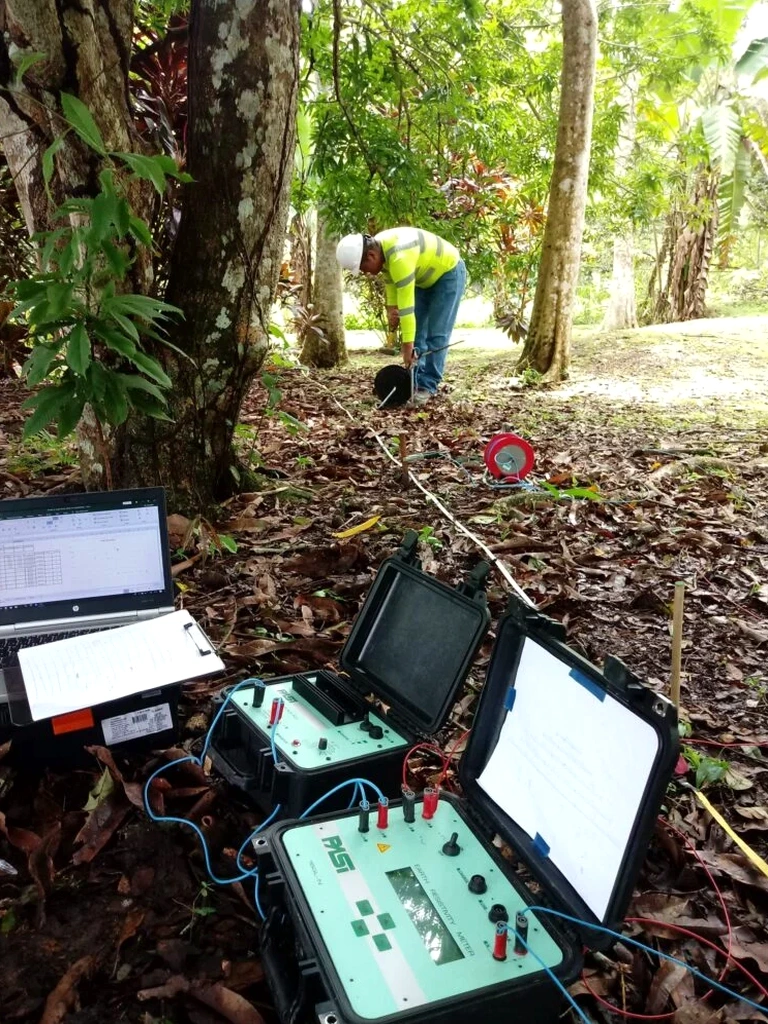
Scope of work in Cambridge Ontario
Critical ground factors in Cambridge Ontario
The Guelph Formation dolostone beneath Cambridge is an irregular bedrock surface, with karstic weathering features documented in boreholes along the Grand River valley. Where the rockhead drops abruptly into a buried gorge, the overlying glacial and post-glacial sediments can exceed 30 meters in thickness, and the contrast in electrical resistivity between sound rock and saturated infill is pronounced. Misinterpreting this boundary can lead to piles designed too short, or to excavations that encounter unexpected groundwater inflow when the till cap is breached. A related hazard is the presence of high-plasticity glaciolacustrine clays in the lowlands east of Highway 24; these materials exhibit resistivity values below 10 Ω·m, and their low bearing capacity demands careful foundation assessment. When resistivity data is combined with slope-stability analysis along the river bluffs, the team identifies zones where elevated pore pressures and weak clay layers create rotational slip risks that are invisible from the surface. The electrical method also helps delineate leachate plumes or saline contamination if the site has an industrial history, a consideration relevant to several brownfield parcels in the Hespeler and Galt districts. Without this geophysical snapshot, the ground model remains incomplete and the residual risk stays with the owner.
Our services
Our resistivity services in Cambridge are designed to answer specific geotechnical questions, from bedrock profiling to contamination mapping. Each survey package includes field acquisition, data processing, and a signed engineering report that correlates geophysics with available borehole logs.
VES Sounding for Bedrock Depth
1D vertical electrical sounding using the Schlumberger array, interpreted against regional stratigraphy to provide depth-to-rock estimates for foundation design and excavation planning in the Galt and Preston neighborhoods.
2D Electrical Resistivity Tomography
Multi-electrode dipole-dipole and Wenner profiles processed with solid inversion to image lateral changes in soil type, locate buried channels, and map the water table across extended linear corridors.
Groundwater and Contaminant Mapping
Resistivity surveys calibrated with in-situ water conductivity measurements to delineate leachate migration, saline intrusion, or perched water zones in brownfield redevelopment sites across Cambridge.
Frequently asked questions
How deep can an electrical resistivity survey investigate in the Cambridge area?
The maximum depth depends on the array spread length and the local geology. With a typical Schlumberger VES using an AB/2 spacing of 150 meters, we can reach depths of roughly 60 to 80 meters in the glacial sediments of Waterloo Region. In practice, the resolution degrades with depth, so we optimize the electrode geometry for the target interval specified by the geotechnical consultant.
What is the typical cost of a resistivity survey in Cambridge?
For a site in Cambridge, a single VES sounding with interpretation generally ranges from CA$880 to CA$1,380, while a 2D tomography line of 200 to 300 meters typically falls within a similar per-line range. The final figure depends on the number of soundings, line length, terrain accessibility, and the level of reporting required.
How do you correlate resistivity values to actual soil types?
We calibrate the geophysical model against direct observations from boreholes or test pits. When a test-pits excavation exposes a specific layer, we measure its resistivity in-situ and use that value to constrain the inversion of the surrounding profile. This empirical link between resistivity and lithology reduces interpretation ambiguity significantly.
Does frozen ground affect the resistivity readings?
Yes, and it is a factor we consider during late-fall to early-spring surveys in Cambridge. Ice is highly resistive, so the near-surface layer can show elevated apparent resistivity that masks the true soil signature. We adjust the array geometry and inversion parameters to account for the frozen crust, and we recommend scheduling surveys between April and November for optimal surface coupling and representative results.